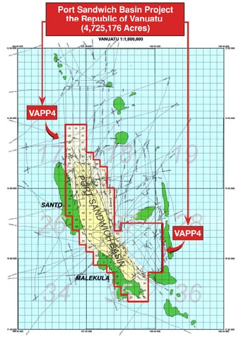
Introduction to Interwest (Vanuatu) Ltd. Port Sandwich Basin Project
Port Sandwich Basin, Republic of Vanuatu 4.7 Million-acre Oil and Gas License Area
Materials reviewed and used for this study include estimates of possible reserves and economic projections, local geology, geophysics, geochemistry and tectonics. Data includes new proprietary material including: geology, geochemistry, Earth Satellite imagery, ocean bottom cores, and re-processed seismic data.
The play envisions source rock, kitchens, carrier-beds, reservoir and seals. All are essentially contiguous and form local geological and tectonic provenance. Indirect evidence indicates they have operated for a sufficient time to satisfy the conditions required for maturation, generation, and migration. This is substantiated by “oil slick earth-satellite imaging”, ocean bottom coring analyses, gas-yielding sea water analyses, gas seeps, carbonates or lithic volcanic calcarenites with respectable TOC contents.
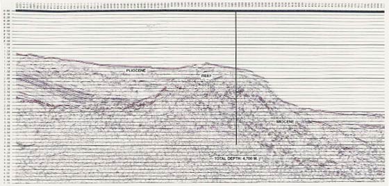
These processes reflect the significant technology advances made in digital recording and processing of seismic data as well as in techniques for seismic prospecting in offshore areas. The new generation of high-speed computer has had an enormous impact on all phases of seismic interpretation and made it possible to obtain critical information from seismic records that originally contained inadequately filtered low and high-velocity reflections of high-noise level seismic data. This exceptional detail obtained from re-processed records is an aid to recognizing identifiable waveforms, differentiating the basement from stratified sedimentary rocks, increasing the reliability of interpretation and mapping new structural leads which might be responsible for entrapment of hydrocarbons.
Broad anticline leads with potential closure provide multiple sedimentary reservoir objectives at estimated drilling depths: ranging from 9,000 to 16,000 ft. -- in ocean floor water depths to 5,000 (±) ft.
Investigative results and presentations in published data indicate carbonate sediments are repetitiously deposited and accumulate in continuous graben. Potential kitchen areas appear to be established where sequences are buried to depths of 2.0 – 3.0 (±)seconds (TWT). Calcareous sediments consist of reefal, bioherm, biostrome and coarse oligometric reef derived carbonates. Combinations of anticipated migration include the Tawoli (U. Miocene) and upper Port Sandwich (M. Miocene) objectives, aided by small, reefal connections between stacked reef bodies. Contemplated biomass sources increase in sinking blocks along with sealing volcanaclastic sequences.
It is Important that this report serves a broader purpose than the simple posting of technical information. In the field of prospecting activity, qualified unexplored areas offer treasures within the earth for extraction of seriously needed energy. There is a tremendous need for unraveling those kinds of strategic resources because it is of particular current importance to maintaining the world’s industrial economy and living standards.